
Talk about going on a mother of all sightseeing....
After going through Chapman's Peak Drive and experiencing the beautiful scenery there, we finally landed up at one of the major tourist attractions in Cape Town - the Cape of Good Hope.
To say that this was a massive piece of attraction would not be doing it justice. There were many things to see but we only got to see a fraction on our visit there.
 |
| The Lighthouse |
Hubby and I had been suffering some sort of ailment when walking too long and too far and so we only managed to get to the top of the Lighthouse (seen above) and to the edge of Cape of Good Hope. According to the picture it is the most southwestern point of the African continent.
There is a slight misconception that the Cape of Good Hope is the most southern tip of Africa. It is believed that the Cape of Good Hope divided the two big Oceans, Atlantic and Indian. In truth, the southernmost point is actually Cape Agulhas, which can be found about 150 kilometres (90 miles) east-southeast from Cape of Good Hope. This is where the two oceans meet. (Information provided by Wikipedia)
To get to the top of the Lighthouse, it was required to ride The Flying Dutchman, which was a 10-minute funicular. There are many paths leading towards the edges of the Cape. The scenery was intense and serene at the same time as you look down below the oceans hitting the rocks but feel the cool breeze of the ocean wind. It was spectacular.
And before you knew it, the day was done. We had lunch at the Two Oceans Restaurant based at the bottom of The Flying Dutchman. Slightly disappointed that I didn't even get to see some shipwrecks that I had on my itinerary. But there is always a next time.
For more information, visit Cape Point.
 |
| Cape Of Good Hope |
There is a slight misconception that the Cape of Good Hope is the most southern tip of Africa. It is believed that the Cape of Good Hope divided the two big Oceans, Atlantic and Indian. In truth, the southernmost point is actually Cape Agulhas, which can be found about 150 kilometres (90 miles) east-southeast from Cape of Good Hope. This is where the two oceans meet. (Information provided by Wikipedia)
 |
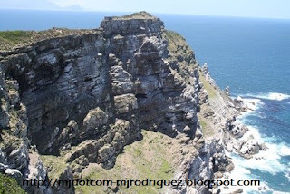
| Is this where the Indian and Atlantic Oceans meet? |
To get to the top of the Lighthouse, it was required to ride The Flying Dutchman, which was a 10-minute funicular. There are many paths leading towards the edges of the Cape. The scenery was intense and serene at the same time as you look down below the oceans hitting the rocks but feel the cool breeze of the ocean wind. It was spectacular.

And before you knew it, the day was done. We had lunch at the Two Oceans Restaurant based at the bottom of The Flying Dutchman. Slightly disappointed that I didn't even get to see some shipwrecks that I had on my itinerary. But there is always a next time.
For more information, visit Cape Point.
No comments:
Post a Comment